
Datei:East of England counties 2009 map.svg

Größe der PNG-Vorschau dieser SVG-Datei: 573 × 600 pixel. Ööder apliasangen: 229 × 240 pixel | 459 × 480 pixel | 734 × 768 pixel | 979 × 1.024 pixel | 1.957 × 2.048 pixel | 1.210 × 1.266 pixel.
Originaal datei (SVG-datei, grate: 1.210 × 1.266 pixel, dateigrate: 2,2 MB)
Beskriiwang
| Beskriiwang |
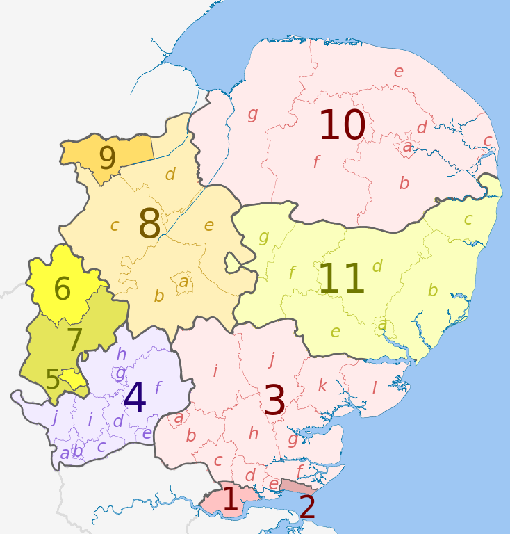
English: Map of the East of England region, showing its counties and administrative districts in 2009. The county colours are the same as those in File:English metropolitan and non-metropolitan counties 2009.svg.
For the districts since 1 April 2019, see File:East of England counties 2019 map.svg Equirectangular map projection on WGS 84 datum, with N/S stretched 160% Geographic limits:
|
| Dootem | (UTC) |
| Kwel |
Diese Datei wurde von diesen Werken abgeleitet: |
| Skriiwer of Konstler |
|
| Ööder wersioonen | File:East of England counties 2019 map.svg – version since 1 April 2019 |


| Map | Ceremonial county | Shire county / unitary | Districts |
|---|---|---|---|
 |
Essex | 1. Thurrock U.A. | |
| 2. Southend-on-Sea U.A. | |||
| 3. Essex | a) Harlow, b) Epping Forest, c) Brentwood, d) Basildon, e) Castle Point, f) Rochford, g) Maldon, h) Chelmsford, i) Uttlesford, j) Braintree, k) Colchester, l) Tendring | ||
| 4. Hertfordshire | a) Three Rivers, b) Watford, c) Hertsmere, d) Welwyn Hatfield, e) Broxbourne, f) East Hertfordshire, g) Stevenage, h) North Hertfordshire, i) St Albans, j) Dacorum | ||
| Bedfordshire | 5. Luton U.A. | ||
| 6. Bedford U.A. | |||
| 7. Central Bedfordshire U.A. | |||
| Cambridgeshire | 8. Cambridgeshire | a) Cambridge, b) South Cambridgeshire, c) Huntingdonshire, d) Fenland, e) East Cambridgeshire | |
| 9. Peterborough U.A. | |||
| 10. Norfolk | a) Norwich, b) South Norfolk, c) Great Yarmouth, d) Broadland, e) North Norfolk, f) Breckland, g) King's Lynn and West Norfolk | ||
| 11. Suffolk | a) Ipswich, b) Suffolk Coastal, c) Waveney, d) Mid Suffolk, e) Babergh, f) St. Edmundsbury, g) Forest Heath | ||
Lisens
Detdiar datei häält en lisens oner det Creative-Commons-lisens „Nööm nääm - Oner salew konditjuunen 3.0. Ei portiaret“.
nööm nääm: Dr Greg and Nilfanion. Contains Ordnance Survey data © Crown copyright and database right 2010
- Dü mutst detdiar werk
- widjer du – detdiar werk kopiare an widjer du
- nei tuupstel – det werk feranre
- Oner jodiar konditjuunen:
- Nööm nääm – Dü skel di nööm faan di skriiwer of konstler nääm. Oober ei so, dat at so ütjsjocht, üs wan hi din werk gud fanjt.
- Oner josalew konditjuunen widjerdu – Wan dü detdiar werk feranerst, skel dü det resultaat oner detsalew lisens widjer du.
Originaal datei-logbuk
This image is a derivative work of the following images:
- File:East_Midlands_districts_2011_map.svg licensed with Cc-by-sa-3.0, GFDL
- 2011-05-01T18:55:02Z Nilfanion 1099x1305 (1687648 Bytes) == Summary == {{Information |Description=Map of the [[w:East Midlands|East Midlands]] region showing the administrative districts. Equirectangular map projection on WGS 84 datum, with N/S stretched 165% Geographic limits: *
- File:English_ceremonial_counties_2010.svg licensed with Cc-by-sa-3.0, GFDL
- 2010-11-23T16:39:55Z Nilfanion 1108x1345 (308868 Bytes) thicker lines
- 2010-11-23T16:20:19Z Nilfanion 1108x1345 (301520 Bytes) tweaks
- 2010-10-26T20:34:20Z Nilfanion 817x990 (1391832 Bytes) {{Information |Description=Map showing the [[w:ceremonial counties of England]] including the City of London, in 2010. Equirectangular map projection on WGS 84 datum, with N/S stretched 170% Geographic limits: *West: 6.75W
Hochgeladen mit derivativeFX
Datei wersioonen
Klike üüb en tidjponkt, am detdiar wersion uuntulukin.
| Dootem/Tidj | Föörskaubil | Miaten | Brüker | Komentaar | |
|---|---|---|---|---|---|
| aktuel | 23:06, 30. Apr. 2012 | | 1.210 × 1.266 (2,2 MB) | Dr Greg | == {{int:filedesc}} == {{Information |Description={{en|Map of the East Midlands region of England, showing its counties and administrative districts. The county colours are the same as those in [[:File:English metropolitan and non-m... |
Hü det datei brükt woort
Detdiar sidj brükt detdiar datei:
Globaal brük faan datein
Jodiar ööder Wikis brük detdiar datei:
- Brük üüb ar.wikipedia.org
- Brük üüb fa.wikipedia.org
- Brük üüb fi.wikipedia.org
- Brük üüb fr.wikipedia.org
- Brük üüb fy.wikipedia.org
- Brük üüb hu.wikipedia.org
- Brük üüb mr.wikipedia.org
- Brük üüb pt.wikipedia.org
- Brük üüb tr.wikipedia.org
- Brük üüb vi.wikipedia.org
- Brük üüb vls.wikipedia.org
- Brük üüb zh-yue.wikipedia.org