Datei:Egypt relief location map 2008 to 2011.jpg

Seiteninhalte werden in anderen Sprachen nicht unterstützt.
Faan Wikipedia

Originaal datei(1.055 × 973 pixels, dateigrate: 451 KB, MIME-typ: image/jpeg)

Detheer bil as faan Wikimedia Commons an koon faan ööder projekten brükt wurd. Det beskriiwang faan't beskriiwangssidj woort oner uunwiset.

Beskriiwang

Beskriiwang
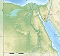
Deutsch: Relief Positionskarte von Ägypten
English: Physical location map of Egypt as it was from April 2008 to April 2011, 14 during the existence of the 6th of October and Helwan Governorates.
Français : Carte physique vierge destinée à la géolocalisation de l'Égypte telle que d'avril 2008 au 14 avril 2011 durant l’existence des gouvernorats du 6 Octobre et de Helwan.

Topographic scale: 1:4,932,000 (precision: 1,233 m)
Equirectangular projection, WGS84 datum

  • Standard meridian: 030° 45' E
  • Central parallel: 26° 42' N

Geographic limits of the map:

  • Top: 32° 06' N
  • Bottom: 21° 18' N
  • Left: 024° 12' E
  • Right: 037° 18' E
Dootem
Kwel

Topographic background map: Own work

  • Source of data: SRTM30 Plus

All other data taken from File:Egypt_location_map.svg created by NordNordWest under GFDL/CC-BY-SA 3.0

  • Sources of data:
    • United States National Imagery and Mapping Agency data
    • World Data Base II data
Skriiwer of Konstler Eric Gaba (Sting - fr:Sting) and NordNordWest
Ferloof
(Hü det datei brükt woort)
Attribution and Share-Alike required
Ööder wersioonen

Equivalent administrative map: former administrative location map

Kameraposition26° 42′ 00″ N, 30° 45′ 00″ O Kartographer map based on OpenStreetMap.Dieses und weitere Bilder auf OpenStreetMapinfo
Kartenwerkstatt
Diese Karte wurde in der Kartenwerkstatt erstellt oder verbessert. Auch du kannst dort Karten vorschlagen, die zu erstellen, verändern oder übersetzen sind.

Lisens

Ik hual a rochten üüb detdiar werk, an du det frei oner a lisensen:
GNU head Dü könst det datei kopiare, widjerdu of feranre efter a reegeln faan't GNU Free Documentation License, wersion 1.2 of leeder faan't Free Software Foundation; diar as niks ünferanerlik an nään tekst üüb a föör- of bääftsidj. Dü könst di lisens tekst efterlees bi GNU Free Documentation License.
w:de:Creative Commons
Nööm nääm Oner josalew konditjuunen widjerdu
Dü mutst detdiar werk
  • widjer du – detdiar werk kopiare an widjer du
  • nei tuupstel – det werk feranre
Oner jodiar konditjuunen:
  • Nööm nääm – Dü skel di nööm faan di skriiwer of konstler nääm. Oober ei so, dat at so ütjsjocht, üs wan hi din werk gud fanjt.
  • Oner josalew konditjuunen widjerdu – Wan dü detdiar werk feranerst, skel dü det resultaat oner detsalew lisens widjer du.
Schük di ian faan jodiar lisensen ütj.

Kurzbeschreibungen

Ergänze eine einzeilige Erklärung, was diese Datei darstellt.

In dieser Datei abgebildete Objekte

motiif

Marts 2010

26°42'0.000"N, 30°45'0.000"E

Datei wersioonen

Klike üüb en tidjponkt, am detdiar wersion uuntulukin.

Dootem/TidjFöörskaubilMiatenBrükerKomentaar
aktuel15:20, 18. Apr. 2011Föörskau för det wersion faan 15:20, 18. Apr. 20111.055 × 973 (451 KB)Sting== {{int:filedesc}} == {{Information |Description= {{de|Relief Positionskarte von Ägypten}} {{en|Physical location map of Egypt as it was from April 2008 to April 2011, 14 during the existence of the [[:en:6th of October Go

Detdiar sidj brükt detdiar datei:

Globaal brük faan datein

Metadooten