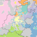
Datei:Gauteng 2001 dominant language map.svg

Größe der PNG-Vorschau dieser SVG-Datei: 595 × 600 pixel. Ööder apliasangen: 238 × 240 pixel | 476 × 480 pixel | 762 × 768 pixel | 1.016 × 1.024 pixel | 2.032 × 2.048 pixel | 996 × 1.004 pixel.
Originaal datei (SVG-datei, grate: 996 × 1.004 pixel, dateigrate: 1,03 MB)
Datei wersioonen
Klike üüb en tidjponkt, am detdiar wersion uuntulukin.
| Dootem/Tidj | Föörskaubil | Miaten | Brüker | Komentaar | |
|---|---|---|---|---|---|
| aktuel | 07:49, 5. Okt. 2010 |  | 996 × 1.004 (1,03 MB) | Htonl | equal-area projection, map styling |
| 13:06, 16. Feb. 2010 |  | 940 × 836 (1,16 MB) | Htonl | size | |
| 21:51, 15. Feb. 2010 |  | 1.000 × 889 (1,14 MB) | Htonl | fix errors | |
| 23:44, 10. Feb. 2010 |  | 1.000 × 889 (1,05 MB) | Htonl | =={{int:filedesc}}== {{Information |Description={{en|1=Map showing the dominant home languages in Gauteng province of South Africa, according to Census 2001 at the "Subplace" level. In this context, a language is dominant if it more than 50% of the popula |
Hü det datei brükt woort
Detdiar sidj brükt detdiar datei:
Globaal brük faan datein
Jodiar ööder Wikis brük detdiar datei:
- Brük üüb af.wikipedia.org
- Brük üüb de.wikipedia.org
- Brük üüb en.wikipedia.org
- Brük üüb fr.wikipedia.org
- Brük üüb he.wikipedia.org
- Brük üüb hy.wikipedia.org
- Brük üüb ja.wikipedia.org
- Brük üüb ka.wikipedia.org
- Brük üüb ru.wikipedia.org
- Brük üüb tg.wikipedia.org
- Brük üüb zh.wikipedia.org
- Brük üüb zu.wikipedia.org

