
Datei:Smithisland milt.jpg

Grate faan detdiar föörskaubil: 549 × 600 pixel. Ööder apliasangen: 220 × 240 pixel | 439 × 480 pixel | 703 × 768 pixel | 1.024 × 1.119 pixel.
Originaal datei (1.024 × 1.119 pixels, dateigrate: 209 KB, MIME-typ: image/jpeg)
Beskriiwang
| Beskriiwang |
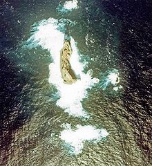
English: Aerial Photograph of Smith Island at Izu Islands in 1978.
日本語: 須美寿島の航空写真(1978年)。1990年代に島が部分的に崩落したため、現在とは形状が異なっている。 |
| Dootem | |
| Kwel |
日本語: 国土画像情報(カラー空中写真) |
| Skriiwer of Konstler |
日本語: 国土交通省 |
Lisens

|
Detheer datei koon faan arken brükt wurd för wat hi wal, wan di skriiwer of konstler the Ministry of Land, Infrastructure, Transport and Tourism of Japan uk näämd woort. Det datei mut feranert wurd an uk tu jil fersiinin brükt wurd. |
nööm nääm:
Copyright © National Land Image Information (Color Aerial Photographs), Ministry of Land, Infrastructure, Transport and Tourism
|
 |
This image is copyrighted by the Ministry of Land, Infrastructure, Transport and Tourism of Japan. For terms of use, see the stipulation to use of National Land Information (in Japanese) and message from MLIT (in Japanese and English). When you display this image on an article, include the following phrase in the description: "Made based on National Land Image Information (Color Aerial Photographs), Ministry of Land, Infrastructure, Transport and Tourism".
|
Datei wersioonen
Klike üüb en tidjponkt, am detdiar wersion uuntulukin.
| Dootem/Tidj | Föörskaubil | Miaten | Brüker | Komentaar | |
|---|---|---|---|---|---|
| aktuel | 16:38, 9. Mei 2006 | | 1.024 × 1.119 (209 KB) | Tdk~commonswiki | Aerial Photograph of Smith Island at Izu Islands in 1978.{{AerialPhotograph-mlitJP}} |
Hü det datei brükt woort
Detdiar sidj brükt detdiar datei:
Globaal brük faan datein
Jodiar ööder Wikis brük detdiar datei:
- Brük üüb arz.wikipedia.org
- Brük üüb az.wikipedia.org
- Brük üüb ceb.wikipedia.org
- Brük üüb ckb.wikipedia.org
- Brük üüb cs.wikipedia.org
- Brük üüb de.wikipedia.org
- Brük üüb en.wikipedia.org
- Brük üüb es.wikipedia.org
- Brük üüb fa.wikipedia.org
- Brük üüb he.wikipedia.org
- Brük üüb hy.wikipedia.org
- Brük üüb it.wikipedia.org
- Brük üüb ja.wikipedia.org
- Brük üüb ko.wikipedia.org
- Brük üüb lt.wikipedia.org
- Brük üüb mr.wikipedia.org
- Brük üüb no.wikipedia.org
- Brük üüb pt.wikipedia.org
- Brük üüb ru.wikipedia.org
- Brük üüb sk.wikipedia.org
- Brük üüb tr.wikipedia.org
- Brük üüb uk.wikipedia.org
- Brük üüb www.wikidata.org
- Brük üüb zh.wikipedia.org