
Datei:Topographic map of the districts of Socotra (de).svg

Größe der PNG-Vorschau dieser SVG-Datei: 800 × 229 pixel. Ööder apliasangen: 320 × 92 pixel | 640 × 183 pixel | 1.024 × 293 pixel | 1.280 × 367 pixel | 2.560 × 733 pixel | 1.309 × 375 pixel.
Originaal datei (SVG-datei, grate: 1.309 × 375 pixel, dateigrate: 412 KB)
Beskriiwang
| Beskriiwang |
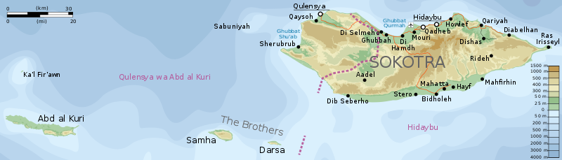
English: Topographic map of the districts of Socotra.
Deutsch: Topographische Karte der Distrikte von Sokotra.
Français : Carte topographique des départements de Socotra.
Македонски: Топографска карта на Сокотра.
Suomi: Sokotran topografinen kartta.
Русский: Топографическая карта Сокотры |
||
| Dootem | |||
| Kwel |
Self-made in Inkscape. |
||
| Skriiwer of Konstler | Oona Räisänen (Mysid) | ||
| Ferloof (Hü det datei brükt woort) |
Ik hual a rochten üüb detdiar werk, an du det frei oner a lisensen:
This file is licensed under the Creative Commons Attribution-Share Alike 4.0 International, 3.0 Unported, 2.5 Generic, 2.0 Generic and 1.0 Generic license.
Schük di ian faan jodiar lisensen ütj. |
||
| Ööder wersioonen |
|

.svg)
.svg)
|
Diese SVG-Datei enthält eingebetteten Text, der mit jedem geeigneten SVG-Editor, Texteditor oder dem SVG-Übersetzungs-Werkzeug in deine Sprache übersetzt werden kann. Für mehr Informationen siehe Über das Übersetzen von SVG-Dateien. |
.svg)
Datei wersioonen
Klike üüb en tidjponkt, am detdiar wersion uuntulukin.
| Dootem/Tidj | Föörskaubil | Miaten | Brüker | Komentaar | |
|---|---|---|---|---|---|
| aktuel | 01:57, 2. Jul. 2017 | 1.309 × 375 (412 KB) | Furfur | == {{int:filedesc}} == {{Information |Description= {{en|Topographic map of the districts of Socotra.}} {{de|Topographische Karte der Distrikte von Sokotra.}} {{fr|Carte topographique des départements de [[:fr:Socotra|So... |
Hü det datei brükt woort
Detdiar sidj brükt detdiar datei:
Globaal brük faan datein
Jodiar ööder Wikis brük detdiar datei:
- Brük üüb de.wikipedia.org
- Brük üüb it.wikipedia.org
- Brük üüb zh.wikipedia.org
.svg)