
Datei:Yorkshire and the Humber counties 2009 map.svg

Größe der PNG-Vorschau dieser SVG-Datei: 705 × 600 pixel. Ööder apliasangen: 282 × 240 pixel | 564 × 480 pixel | 903 × 768 pixel | 1.204 × 1.024 pixel | 2.408 × 2.048 pixel | 1.425 × 1.212 pixel.
Originaal datei (SVG-datei, grate: 1.425 × 1.212 pixel, dateigrate: 1,25 MB)
Beskriiwang
| Beskriiwang |
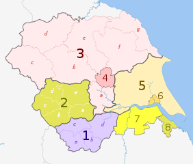
English: Map of the Yorkshire and the Humber region of England, showing its counties and administrative districts until 31 March 2023. The county colours are the same as those in File:English metropolitan and non-metropolitan counties 2009.svg.
For districts after 1 April 2023, see File:Yorkshire and the Humber counties 2023 map.svg. Equirectangular map projection on WGS 84 datum, with N/S stretched 170% Geographic limits:
|
| Dootem | (UTC) |
| Kwel |
Diese Datei wurde von diesen Werken abgeleitet: |
| Skriiwer of Konstler |
|
| Ööder wersioonen |
|

| Map | Ceremonial county | County / unitary | Districts |
|---|---|---|---|
 |
1. South Yorkshire * | a) Sheffield, b) Rotherham, c) Barnsley, d) Doncaster | |
| 2. West Yorkshire * | a) Wakefield, b) Kirklees, c) Calderdale, d) Bradford, e) Leeds | ||
| North Yorkshire (part only) |
3. North Yorkshire † | a) Selby, b) Harrogate, c) Craven, d) Richmondshire, e) Hambleton, f) Ryedale, g) Scarborough | |
| 4. York U.A. | |||
| East Riding of Yorkshire | 5. East Riding of Yorkshire U.A. | ||
| 6. Kingston upon Hull U.A. | |||
| Lincolnshire (part only) |
7. North Lincolnshire U.A. | ||
| 8. North East Lincolnshire U.A. | |||
Key: †shire county | *metropolitan county
Lisens
Detdiar datei häält en lisens oner det Creative-Commons-lisens „Nööm nääm - Oner salew konditjuunen 3.0. Ei portiaret“.
nööm nääm: Dr Greg and Nilfanion. Contains Ordnance Survey data © Crown copyright and database right 2011
- Dü mutst detdiar werk
- widjer du – detdiar werk kopiare an widjer du
- nei tuupstel – det werk feranre
- Oner jodiar konditjuunen:
- Nööm nääm – Dü skel di nööm faan di skriiwer of konstler nääm. Oober ei so, dat at so ütjsjocht, üs wan hi din werk gud fanjt.
- Oner josalew konditjuunen widjerdu – Wan dü detdiar werk feranerst, skel dü det resultaat oner detsalew lisens widjer du.
Originaal datei-logbuk
This image is a derivative work of the following images:
- File:Yorkshire_and_the_Humber_districts_2011_map.svg licensed with Cc-by-sa-3.0, GFDL
- 2011-05-01T19:07:00Z Nilfanion 1425x1212 (1275424 Bytes) == Summary == {{Information |Description=Map of the [[w:Yorkshire and the Humber|Yorkshire and the Humber]] region showing the administrative districts. Equirectangular map projection on WGS 84 datum, with N/S stretched 170%
- File:English_ceremonial_counties_2010.svg licensed with Cc-by-sa-3.0, GFDL
- 2010-11-23T16:39:55Z Nilfanion 1108x1345 (308868 Bytes) thicker lines
- 2010-11-23T16:20:19Z Nilfanion 1108x1345 (301520 Bytes) tweaks
- 2010-10-26T20:34:20Z Nilfanion 817x990 (1391832 Bytes) {{Information |Description=Map showing the [[w:ceremonial counties of England]] including the City of London, in 2010. Equirectangular map projection on WGS 84 datum, with N/S stretched 170% Geographic limits: *West: 6.75W
Hochgeladen mit derivativeFX
Datei wersioonen
Klike üüb en tidjponkt, am detdiar wersion uuntulukin.
| Dootem/Tidj | Föörskaubil | Miaten | Brüker | Komentaar | |
|---|---|---|---|---|---|
| aktuel | 23:38, 2. Mei 2012 | | 1.425 × 1.212 (1,25 MB) | Dr Greg | == {{int:filedesc}} == {{Information |Description={{en|Map of the Yorkshire and the Humber region of England, showing its counties and administrative districts. The county colours are the same as those in [[:File:English ... |
Hü det datei brükt woort
Detdiar sidj brükt detdiar datei:
Globaal brük faan datein
Jodiar ööder Wikis brük detdiar datei:
- Brük üüb ar.wikipedia.org
- Brük üüb bn.wikipedia.org
- Brük üüb en.wikipedia.org
- Brük üüb fa.wikipedia.org
- Brük üüb fr.wikipedia.org
- Brük üüb hr.wikipedia.org
- Brük üüb hu.wikipedia.org
- Brük üüb mr.wikipedia.org
- Brük üüb mzn.wikipedia.org
- Brük üüb pl.wikipedia.org
- Brük üüb pnb.wikipedia.org
- Brük üüb pt.wikipedia.org
- Brük üüb th.wikipedia.org
- Brük üüb ur.wikipedia.org
- Brük üüb vi.wikipedia.org
- Brük üüb vls.wikipedia.org
- Brük üüb zh-yue.wikipedia.org