
Datei:Arctic Ocean relief location map.png

Grate faan detdiar föörskaubil: 600 × 600 pixel. Ööder apliasangen: 240 × 240 pixel | 480 × 480 pixel | 768 × 768 pixel | 1.181 × 1.181 pixel.
Originaal datei (1.181 × 1.181 pixels, dateigrate: 2,19 MB, MIME-typ: image/png)
Beskriiwang
| Beskriiwang |
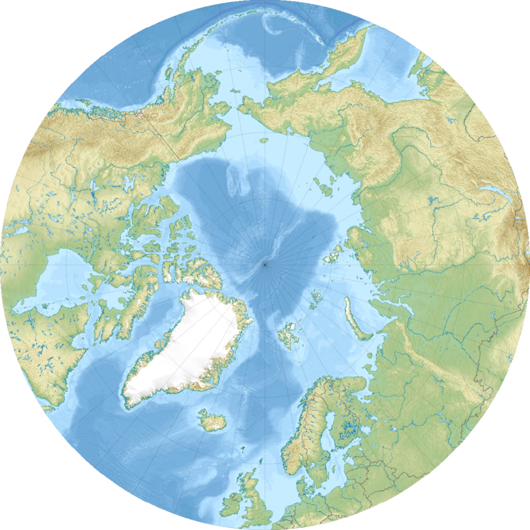
English: Relief location map of the Arctic Ocean.
|
| Dootem | |
| Kwel | Aanj werk |
| Skriiwer of Konstler | Uwe Dedering |
| Ööder wersioonen |
|

Lisens
Ik hual a rochten üüb detdiar werk, an du det frei oner a lisensen:
Detdiar datei häält en lisens oner det Creative-Commons-lisens „Nööm nääm - Oner salew konditjuunen 3.0. Ei portiaret“.
- Dü mutst detdiar werk
- widjer du – detdiar werk kopiare an widjer du
- nei tuupstel – det werk feranre
- Oner jodiar konditjuunen:
- Nööm nääm – Dü skel di nööm faan di skriiwer of konstler nääm. Oober ei so, dat at so ütjsjocht, üs wan hi din werk gud fanjt.
- Oner josalew konditjuunen widjerdu – Wan dü detdiar werk feranerst, skel dü det resultaat oner detsalew lisens widjer du.

|
Dü könst det datei kopiare, widjerdu of feranre efter a reegeln faan't GNU Free Documentation License, wersion 1.2 of leeder faan't Free Software Foundation; diar as niks ünferanerlik an nään tekst üüb a föör- of bääftsidj. Dü könst di lisens tekst efterlees bi GNU Free Documentation License. |
Schük di ian faan jodiar lisensen ütj.
Datei wersioonen
Klike üüb en tidjponkt, am detdiar wersion uuntulukin.
| Dootem/Tidj | Föörskaubil | Miaten | Brüker | Komentaar | |
|---|---|---|---|---|---|
| aktuel | 10:49, 24. Det. 2010 | | 1.181 × 1.181 (2,19 MB) | Uwe Dedering | {{Information |Description={{en|1= Relief location map of the Arctic Ocean. * Projection: Azimuthal equidistant projection. * Area of interest: :* N: 90.0° N :* S: 50.0° N :* W: -180.0° E :* E: 180.0° E * Projection center: :* NS: 90° N :* WE: 0° E |
Hü det datei brükt woort
Detdiar sidj brükt detdiar datei:
Globaal brük faan datein
Jodiar ööder Wikis brük detdiar datei:
- Brük üüb ar.wikipedia.org
- Brük üüb ast.wikipedia.org
- Brük üüb az.wikipedia.org
- Brük üüb ban.wikipedia.org
- Brük üüb be-tarask.wikipedia.org
- Brük üüb ceb.wikipedia.org
- Brük üüb ce.wikipedia.org
- Brük üüb cs.wikipedia.org
- Brük üüb de.wikipedia.org
- Brük üüb dsb.wikipedia.org
- Brük üüb en.wikipedia.org
- Kara Sea
- White Sea
- Ilulissat
- East Siberian Sea
- Kursk submarine disaster
- Lincoln Sea
- ATOW1996
- Jan Mayensfield
- Litke Deep
- Pechora Sea
- Molloy Deep
- Prince Gustaf Adolf Sea
- 83-42
- Module:Location map/data/Arctic/doc
- User:Dino/sandbox
- Greenland Plain
- York Mountains
- Iversenfjellet
- Keilhaufjellet
- Lake North Pole
- Hovtinden
Muar globaal brük faan detdiar datei.