
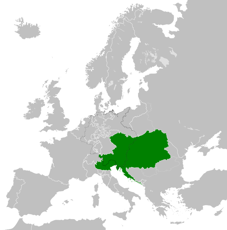
Datei:Austrian Empire (1815).svg

Größe der PNG-Vorschau dieser SVG-Datei: 450 × 456 pixel. Ööder apliasangen: 237 × 240 pixel | 474 × 480 pixel | 758 × 768 pixel | 1.011 × 1.024 pixel | 2.021 × 2.048 pixel.
Originaal datei (SVG-datei, grate: 450 × 456 pixel, dateigrate: 691 KB)
Beskriiwang


.svg)
.svg)
.svg)
.svg)
.svg)


.svg)
.svg)
.svg)


.png)
.png)


.svg)


.svg)

.svg)


.svg)
.svg)
.svg)
.svg)


.svg)
.png)


.svg)


.svg)
.svg)


.svg)


.svg)


.svg)
.svg)
.svg)
.svg)
.svg)
.svg)
.svg)
.svg)
_cropped.svg)
.svg)
.svg)
.svg)
.svg)
.svg)
.svg)
.svg)
.svg)
.svg)
.svg)
.svg)
.svg)
.svg)
.svg)
.svg)
.svg)
.svg)
.svg)
.svg)
.svg)
.svg)
.svg)
.svg)
.svg)
.svg)
.svg)
.svg)
.svg)
.svg)
.svg)
.svg)
.svg)
.svg)
.svg)
.svg)
.svg)
.svg)
.svg)
.svg)
.svg)
.svg)
.svg)
.svg)
.svg)
.svg)
Datei wersioonen
Klike üüb en tidjponkt, am detdiar wersion uuntulukin.
| Dootem/Tidj | Föörskaubil | Miaten | Brüker | Komentaar | |
|---|---|---|---|---|---|
| aktuel | 11:58, 16. Apr. 2019 | | 450 × 456 (691 KB) | TRAJAN 117 | +++ |
| 23:20, 12. Aug. 2013 |  | 450 × 456 (654 KB) | TRAJAN 117 | Update | |
| 07:47, 12. Aug. 2013 |  | 450 × 456 (1 MB) | TRAJAN 117 | {{Information |Description ={{en|1=The Austrian Empire in 1815.}} |Source ={{own}} {{AttribSVG|Blank map of Europe 1815.svg|Alphathon}} |Author =TRAJAN 117 {{created with Inkscape}} |Date =2013-08-12 |Pe... |
Hü det datei brükt woort
Detdiar sidj brükt detdiar datei:
Globaal brük faan datein
Jodiar ööder Wikis brük detdiar datei:
- Brük üüb af.wikipedia.org
- Brük üüb ast.wikipedia.org
- Brük üüb azb.wikipedia.org
- Brük üüb ba.wikipedia.org
- Brük üüb bg.wikipedia.org
- Brük üüb br.wikipedia.org
- Brük üüb ce.wikipedia.org
- Brük üüb cs.wikipedia.org
- Brük üüb cy.wikipedia.org
- Brük üüb de.wikipedia.org
- Brük üüb el.wikipedia.org
- Brük üüb en.wikipedia.org
- Brük üüb es.wikipedia.org
- Brük üüb fi.wikipedia.org
- Brük üüb fr.wikipedia.org
- Brük üüb ga.wikipedia.org
- Brük üüb gd.wikipedia.org
- Brük üüb gl.wikipedia.org
- Brük üüb he.wikipedia.org
- Brük üüb hi.wikipedia.org
- Brük üüb hr.wikipedia.org
- Brük üüb hy.wikipedia.org
- Brük üüb id.wikipedia.org
- Brük üüb id.wikibooks.org
- Brük üüb incubator.wikimedia.org
- Brük üüb is.wikipedia.org
- Brük üüb it.wikipedia.org
- Brük üüb jam.wikipedia.org
- Brük üüb ja.wikipedia.org
- Brük üüb ka.wikipedia.org
- Brük üüb km.wikipedia.org
- Brük üüb ko.wikipedia.org
- Brük üüb ky.wikipedia.org
- Brük üüb lmo.wikipedia.org
- Brük üüb lt.wikipedia.org
- Brük üüb lv.wikipedia.org
- Brük üüb mk.wikipedia.org
- Brük üüb mn.wikipedia.org
- Brük üüb nap.wikipedia.org
- Brük üüb nl.wikipedia.org
- Brük üüb pa.wikipedia.org
Muar globaal brük faan detdiar datei.
.svg)
.svg)