
Datei:Bay of Bengal map ta.svg

Größe der PNG-Vorschau dieser SVG-Datei: 605 × 599 pixel. Ööder apliasangen: 242 × 240 pixel | 485 × 480 pixel | 775 × 768 pixel | 1.034 × 1.024 pixel | 2.068 × 2.048 pixel | 1.662 × 1.646 pixel.
Originaal datei (SVG-datei, grate: 1.662 × 1.646 pixel, dateigrate: 511 KB)
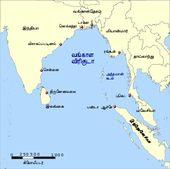
| Beskriiwang | A map showing the location of the Bay of Bengal and the Andaman Sea in southeast Asia. |
| Dootem | (UTC) |
| Kwel | |
| Skriiwer of Konstler |
|
| Ööder wersioonen |
|


| Dieses Bild wurde digital nachbearbeitet. Folgende Änderungen wurden vorgenommen: Vector version, Tamil. Das Originalbild kann hier eingesehen werden: Red pog.svg:
|

|
Dü könst det datei kopiare, widjerdu of feranre efter a reegeln faan't GNU Free Documentation License, wersion 1.2 of leeder faan't Free Software Foundation; diar as niks ünferanerlik an nään tekst üüb a föör- of bääftsidj. Dü könst di lisens tekst efterlees bi GNU Free Documentation License. |
| Detdiar datei häält en lisens oner det Creative-Commons-lisens „Nööm nääm - Oner salew konditjuunen 3.0. Ei portiaret“. | ||
| ||
| Detdiar lisenstiaken kaam mä't GFDL lisens update. |
Originaal datei-logbuk
This image is a derivative work of the following images:
- Image:Bay_of_Bengal_map.png licensed with GFDL
- 2006-02-06T14:47:19Z NormanEinstein 1000x1019 (349850 Bytes) Corrected typo.
- 2005-09-15T20:33:04Z NormanEinstein 800x814 (268248 Bytes) A map showing the location of the Bay of Bengal and the Andaman Sea in southeast Asia. Created by NormanEinstein, September 15, 2005. {{GFDL-self}} [[Category:Maps of Seas]]
- Image:Asia98.svg licensed with PD-USGov
- 2007-10-23T04:49:13Z Brianski 8000x4390 (9380412 Bytes) == NOTE! == This file is very large. It takes >2GB of memory just to open it in inkscape. == Summary == {{Information |Description=Map of Asia as of 1998, with first level administrative units. See also [[:Image:World98.svg]
- Image:Red_pog.svg licensed with PD-self
- 2006-11-23T04:33:54Z Andux 64x64 (607 Bytes) Reverted to earlier revision
- 2006-11-19T18:20:08Z Minestrone 10x10 (16830 Bytes)
- 2006-11-19T18:18:25Z Minestrone 10x10 (16830 Bytes) radial gradient added to fill to give 3d effect (see: [[:en:Image:Locator Dot.svg]])
- 2006-06-26T09:07:26Z Andux 64x64 (607 Bytes) a little brighter
- 2006-06-26T08:35:17Z Andux 64x64 (607 Bytes) Shiny red button/marker widget. [[Category:Icons]][[Category:Buttons]]
Datei wersioonen
Klike üüb en tidjponkt, am detdiar wersion uuntulukin.
| Dootem/Tidj | Föörskaubil | Miaten | Brüker | Komentaar | |
|---|---|---|---|---|---|
| aktuel | 10:14, 22. Sep. 2008 | | 1.662 × 1.646 (511 KB) | Trengarasu | {{Information |Description=A map showing the location of the Bay of Bengal and the Andaman Sea in southeast Asia. |Source=*Image:Bay_of_Bengal_map.png *Image:Asia98.svg *Image:Red_pog.svg |Date=2008-09-22 08:11 (UTC) |Author=*derivative |
Hü det datei brükt woort
Nään artiikel brükt detheer datei
Globaal brük faan datein
Jodiar ööder Wikis brük detdiar datei:
- Brük üüb de.wikipedia.org
- Brük üüb ta.wikipedia.org