
Datei:City of London skyline from London City Hall - Oct 2008.jpg

Grate faan detdiar föörskaubil: 800 × 420 pixel. Ööder apliasangen: 320 × 168 pixel | 640 × 336 pixel | 1.024 × 537 pixel | 1.280 × 671 pixel | 2.560 × 1.343 pixel | 8.441 × 4.427 pixel.
Originaal datei (8.441 × 4.427 pixels, dateigrate: 10,81 MB, MIME-typ: image/jpeg)
Beskriiwang
| Beskriiwang |
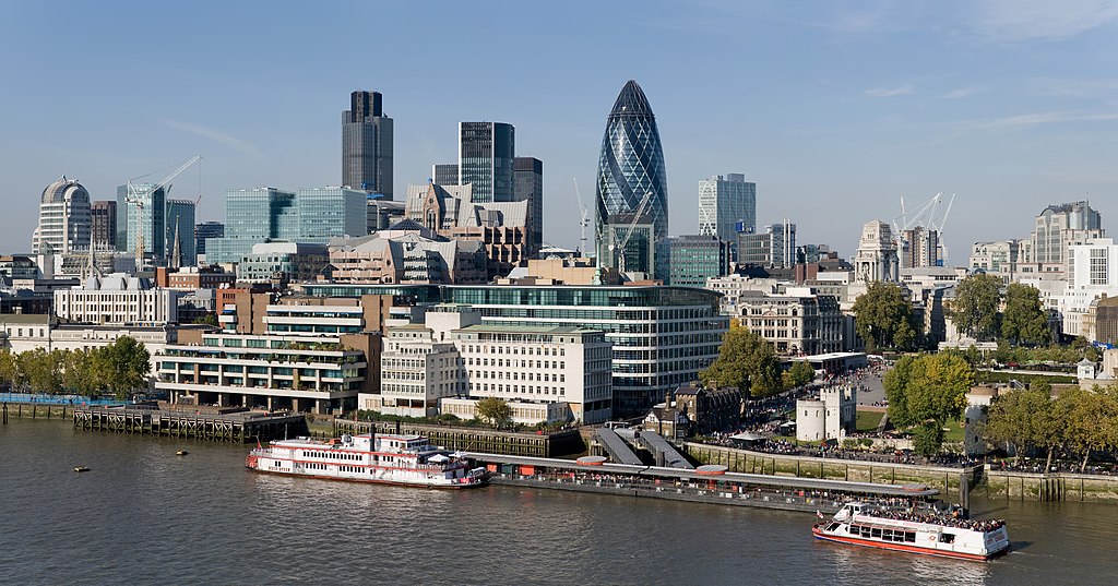
English: The City of London skyline as viewed toward the north-west from the top floor viewing platform of London City Hall on the southern side of the Thames. In the foreground: Dixie Queen and Millennium Time at Tower Millennium Pier. This is a 5 segment panoramic image taken by myself with a Canon 5D and 24-105mm f/4L IS lens. |
| Dootem | |
| Kwel | Aanj werk |
| Skriiwer of Konstler | Diliff |
| Ferloof (Hü det datei brükt woort) |
Summary:In using this image or any subsequent derivatives of it, you are required to release the image under the same license. As such, any reproduction of this image, in any medium, must appear with a copy of, or full URL of the license.Attribution of this image to the author (DAVID ILIFF) is also required, preferably in a prominent location near the image.No other conditions may be added to, or removed from this license without the permission of the author and copyright holder.Suggested attribution: "Photo by DAVID ILIFF. License: CC BY-SA 3.0"Please review the full license requirements carefully before using this image. If you would like to clarify the terms of the license or negotiate less restrictive commercial licensing outside of the bounds of GFDL/CC-BY-SA, please contact me by email, or if you don't have a Wikipedia account you can either leave a message on my talk page with your contact details and your request, or you can contact me on Facebook. Please also send a 'friend request' to ensure that I am aware of your message. |
| Ööder wersioonen |
  |
| Kameraposition | | Dieses und weitere Bilder auf OpenStreetMap |
|---|
Lisens
Ik hual a rochten üüb detdiar werk, an du det frei oner a lisensen:
Detdiar datei häält en lisens oner det Creative-Commons-lisens „Nööm nääm - Oner salew konditjuunen 3.0. Ei portiaret“.
- Dü mutst detdiar werk
- widjer du – detdiar werk kopiare an widjer du
- nei tuupstel – det werk feranre
- Oner jodiar konditjuunen:
- Nööm nääm – Dü skel di nööm faan di skriiwer of konstler nääm. Oober ei so, dat at so ütjsjocht, üs wan hi din werk gud fanjt.
- Oner josalew konditjuunen widjerdu – Wan dü detdiar werk feranerst, skel dü det resultaat oner detsalew lisens widjer du.

|
Dü könst det datei kopiare, widjerdu of feranre efter a reegeln faan't GNU Free Documentation License, wersion 1.2 of leeder faan't Free Software Foundation; diar as niks ünferanerlik an nään tekst üüb a föör- of bääftsidj. Dü könst di lisens tekst efterlees bi GNU Free Documentation License. |
Schük di ian faan jodiar lisensen ütj.
Auszeichnungen
|
Dieses Bild wurde unter Berücksichtigung der Leitlinie für Qualitätsbilder bewertet und gilt als Qualitätsbild.
|
| Annotations | This image is annotated: View the annotations at Commons |
Datei wersioonen
Klike üüb en tidjponkt, am detdiar wersion uuntulukin.
| Dootem/Tidj | Föörskaubil | Miaten | Brüker | Komentaar | |
|---|---|---|---|---|---|
| aktuel | 09:41, 24. Jun. 2012 | | 8.441 × 4.427 (10,81 MB) | Tim! | Reverted to version as of 12:54, 12 October 2008 |
| 14:54, 12. Okt. 2008 |  | 8.441 × 4.427 (10,81 MB) | Diliff | {{Information |Description={{en|1=The City of London skyline as viewed toward the north-west from the top floor viewing platform of London City Hall on the southern side of the Thames. This is a 5 segment panoramic image taken by myself with a Canon 5D an |
Hü det datei brükt woort
Nään artiikel brükt detheer datei
Globaal brük faan datein
Jodiar ööder Wikis brük detdiar datei:
- Brük üüb af.wikipedia.org
- Brük üüb ar.wikipedia.org
- Brük üüb az.wikipedia.org
- Brük üüb az.wiktionary.org
- Brük üüb be-tarask.wikipedia.org
- Brük üüb be.wikipedia.org
- Brük üüb bg.wikipedia.org
- Brük üüb bs.wikipedia.org
- Brük üüb ca.wikipedia.org
- Brük üüb cy.wikipedia.org
- Brük üüb de.wikipedia.org
- Brük üüb en.wikipedia.org
- Tower Millennium Pier
- Wikipedia:WikiProject UK geography
- Wikipedia talk:WikiProject UK geography
- User:Diliff
- Portal:London/Pictures/Wikipedia featured pictures
- Wikipedia:Featured pictures/Places/Panorama
- Portal:United Kingdom/Featured picture
- Wikipedia:WikiProject UK geography/Announcements
- Wikipedia:Featured pictures thumbs/13
- Metropolis
- Wikipedia:Featured picture candidates/October-2008
- Wikipedia:Featured picture candidates/City of London skyline
- Wikipedia:Wikipedia Signpost/2008-11-08/Features and admins
- Wikipedia:Wikipedia Signpost/2008-11-08/SPV
- Wikipedia:Picture of the day/June 2009
- Template:POTD/2009-06-08
- User talk:Diliff/Archive6
- List of central business districts
- Wake Up to Money
- User:Quibik/Montage
- Portal:London/Featured picture
- Portal:London/Featured picture/12
- User talk:Sabrebd/Autoarchive 4
- Talk:United Kingdom/Archive 27
- User talk:Ottoniel B
- Portal:United Kingdom/Featured picture/47
- Talk:London/Archive 11
- Template:User Part Time Resident-London
- User:DexDor/Categorization
Muar globaal brük faan detdiar datei.