
Datei:Emi Koussi Volcano, Chad From ISS.JPG
Grate faan detdiar föörskaubil: 800 × 532 pixel. Ööder apliasangen: 320 × 213 pixel | 640 × 425 pixel | 1.024 × 681 pixel | 1.280 × 851 pixel | 2.560 × 1.701 pixel | 4.288 × 2.850 pixel.
Originaal datei (4.288 × 2.850 pixels, dateigrate: 2,75 MB, MIME-typ: image/jpeg)
Beskriiwang
| Beskriiwang |
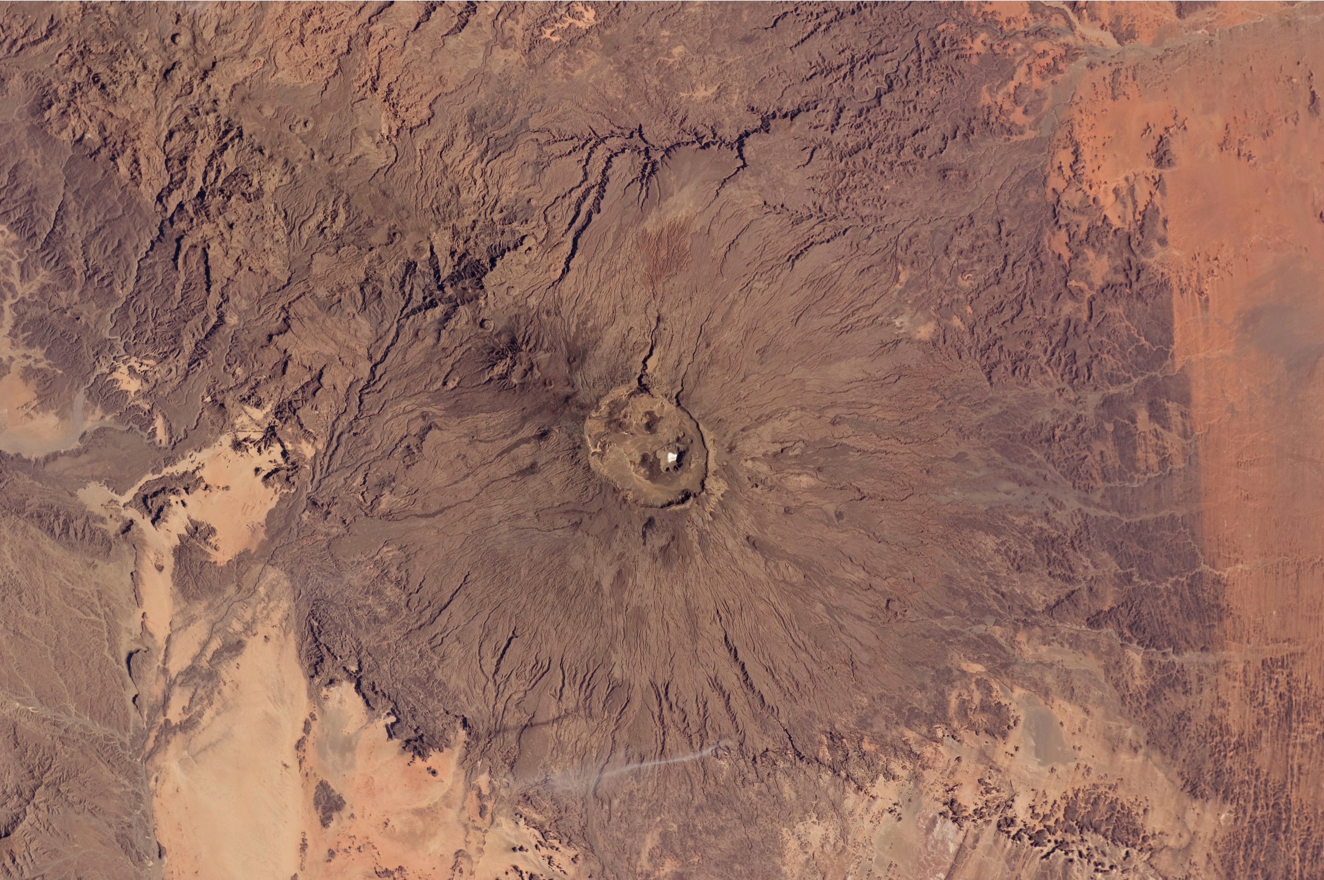
English: The broad Emi Koussi volcano is a shield volcano located in northern Chad, at the south-eastern end of the Tibesti Range. The dark volcanic rocks of the volcano provide a sharp contrast to the underlying tan and light brown sandstone exposed to the west, south, and east (image lower left, lower right, and upper right). This astronaut photograph highlights the entire volcanic structure. At 3,415 meters above sea level, Emi Koussi is the highest summit of Africa's Sahara region. The summit includes three calderas formed by powerful eruptions. Two older and overlapping calderas form a depression approximately 12 kilometres by 15 kilometres in area bounded by a distinct rim (image centre). The youngest and smallest caldera, Era Kohor, formed as a result of eruptive activity within the past 2 million years. |
| Dootem | |
| Kwel | NASA Earth Observatory |
| Skriiwer of Konstler | ISS Expedition 26 crew |
| Kameraposition | | Dieses und weitere Bilder auf OpenStreetMap |
|---|
Diese Mediendatei wurde vom Johnson Space Center der US-amerikanischen National Aeronautics and Space Administration (NASA) unter der Datei-ID ISS026-E-17074 kategorisiert. Diese Markierung zeigt nicht den Urheberrechtsstatus des zugehörigen Werks an. Es ist in jedem Falle zusätzlich eine normale Lizenzvorlage erforderlich. Siehe Commons:Lizenzen für weitere Informationen. Sprachen:
|
Image acquired with a Nikon D2Xs digital camera using a 70 mm lens, and is provided by the ISS Crew Earth Observations experiment and Image Science & Analysis Laboratory, Johnson Space Center.
Lisens
Diese Datei ist gemeinfrei (public domain), da sie vom Image Science & Analysis Laboratory der NASA erstellt worden ist. Die NASA-Urheberrechtsrichtlinie besagt, dass „NASA-Material nicht durch Urheberrecht geschützt ist, wenn es nicht anders angegeben ist“ (NASA-Urheberrechtsrichtlinien-Seite oder Nutzungsbedingungen für Fotos von Astronauten). Die Aufnahme ist Teil der Reihe The Gateway to Astronaut Photography of Earth. Bildquelle: ISS026-E-17074.
|
| Bildnotizen | Diese Datei ist annotiert: Betrachte diese auf Commons. |
Datei wersioonen
Klike üüb en tidjponkt, am detdiar wersion uuntulukin.
| Dootem/Tidj | Föörskaubil | Miaten | Brüker | Komentaar | |
|---|---|---|---|---|---|
| aktuel | 14:50, 14. Feb. 2011 | | 4.288 × 2.850 (2,75 MB) | Originalwana | {{Information |Description ={{en|1=The broad Emi Koussi volcano is a shield volcano located in northern Chad, at the south-eastern end of the Tibesti Range. The dark volcanic rocks of the volcano provide a sharp contrast to the u |
Hü det datei brükt woort
Detdiar sidj brükt detdiar datei:
Globaal brük faan datein
Jodiar ööder Wikis brük detdiar datei:
- Brük üüb ar.wikipedia.org
- Brük üüb ca.wikipedia.org
- Brük üüb cs.wikipedia.org
- Brük üüb de.wikipedia.org
- Brük üüb en.wikipedia.org
- Brük üüb fa.wikipedia.org
- Brük üüb fi.wikipedia.org
- Brük üüb fr.wikipedia.org
- Brük üüb ja.wikipedia.org
- Brük üüb mk.wikipedia.org
- Brük üüb oc.wikipedia.org
- Brük üüb ru.wikipedia.org
- Brük üüb smn.wikipedia.org
- Brük üüb uk.wikipedia.org
- Brük üüb www.wikidata.org