
Datei:Georgia topographic map-fr.svg

Größe der PNG-Vorschau dieser SVG-Datei: 707 × 385 pixel. Ööder apliasangen: 320 × 174 pixel | 640 × 349 pixel | 1.024 × 558 pixel | 1.280 × 697 pixel | 2.560 × 1.394 pixel.
Originaal datei (SVG-datei, grate: 707 × 385 pixel, dateigrate: 3,52 MB)
Beskriiwang
| Beskriiwang |
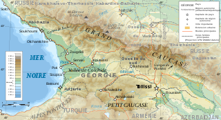
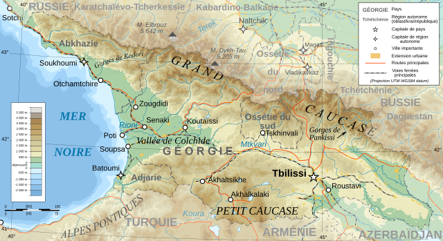
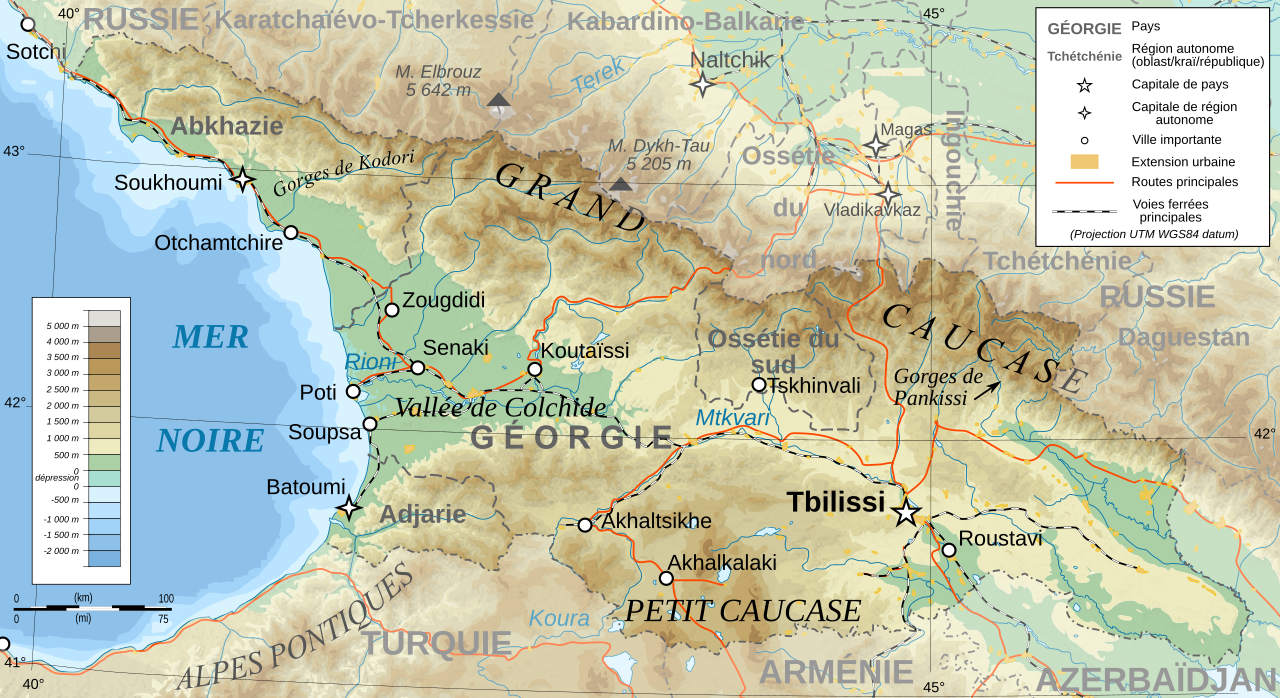
Deutsch: Topographische Karte von Georgien, französische Version English: Topographic map in French of Georgia Français : Carte topographique en français de la Géorgie |
| Dootem | |
| Kwel |
English: Own work ; Topographic data from the NASA Shuttle Radar Topography Mission (SRTM3 v.2) (public domain) edited with 3DEM, reprojected in UTM with GDAL (GDAL), and vectorized with Inkscape ; UTM projection ; WGS84 datum ; shaded relief (composite image of N-W, W and N lightning positions) ; Reference used for the additional data : * Rivers, cities, railroads, routes, bathymetry : Demis add-on for World Wind (see the approval e-mail and the Demis forum) ; * Borders and coast : World data bank II ; Approximate scale of topographic data : 1:1,463,000 ; Note : The shaded relief is a raster image embedded in the SVG file. Français : Création personnelle ; Données topographiques de la NASA Shuttle Radar Topography Mission (SRTM3 v.2) (domaine public) éditées avec 3DEM, reprojetées en UTM avec GDAL et vectorisées avec Inkscape ; projection UTM ; WGS84 datum ; relief ombré (image composite d'éclairages du N-O, O et N) ; Références utilisées pour les données complémentaires : * Rivières, villes, chemins de fers, routes, bathymétrie : Demis add-on for World Wind (cf. l'e-mail d'approbation de Demis et le Demis forum) ; * Frontières et côtes : World data bank II ; Échelle approximative des données topographiques : 1:1 463 000 ; Note : Le relief ombré est une image bitmap embarquée dans le fichier SVG. |
| Skriiwer of Konstler | Bourrichon - fr:Bourrichon |
| Ferloof (Hü det datei brükt woort) |
GFDL / Attribution and Share-Alike required |
| Ööder wersioonen |
Derivative works of this file: Georgia topographic map-blanked.svg
|


|
This SVG file contains embedded text that can be translated into your language, using any capable SVG editor, text editor or the SVG Translate tool. For more information see: About translating SVG files. |
Lisens
Ik hual a rochten üüb detdiar werk, an du det frei oner a lisensen:

|
Dü könst det datei kopiare, widjerdu of feranre efter a reegeln faan't GNU Free Documentation License, wersion 1.2 of leeder faan't Free Software Foundation; diar as niks ünferanerlik an nään tekst üüb a föör- of bääftsidj. Dü könst di lisens tekst efterlees bi GNU Free Documentation License. |
This file is licensed under the Creative Commons Attribution-Share Alike 4.0 International, 3.0 Unported, 2.5 Generic, 2.0 Generic and 1.0 Generic license.
- Dü mutst detdiar werk
- widjer du – detdiar werk kopiare an widjer du
- nei tuupstel – det werk feranre
- Oner jodiar konditjuunen:
- Nööm nääm – Dü skel di nööm faan di skriiwer of konstler nääm. Oober ei so, dat at so ütjsjocht, üs wan hi din werk gud fanjt.
- Oner josalew konditjuunen widjerdu – Wan dü detdiar werk feranerst, skel dü det resultaat oner detsalew lisens widjer du.
Schük di ian faan jodiar lisensen ütj.
Datei wersioonen
Klike üüb en tidjponkt, am detdiar wersion uuntulukin.
| Dootem/Tidj | Föörskaubil | Miaten | Brüker | Komentaar | |
|---|---|---|---|---|---|
| aktuel | 16:57, 13. Jan. 2020 | | 707 × 385 (3,52 MB) | Takhirgeran Umar | clarification |
| 23:43, 30. Mar. 2009 |  | 707 × 385 (3,52 MB) | Bourrichon | +Daguestan | |
| 20:09, 13. Mar. 2009 |  | 707 × 385 (3,52 MB) | Bourrichon | + longitude | |
| 20:01, 13. Mar. 2009 |  | 707 × 385 (3,52 MB) | Bourrichon | -Iran | |
| 19:38, 13. Mar. 2009 |  | 707 × 385 (4,55 MB) | Bourrichon | + Gorges | |
| 19:32, 13. Mar. 2009 |  | 707 × 385 (4,52 MB) | Bourrichon | == Summary == {{Information |Description={{de|Topographische Karte von Georgien, französische Version}}{{en|Topographic map in French of Georgia}}{{fr|Carte topographique en français de la [[:fr:Géorgie (pays)|Géorgie] |
Hü det datei brükt woort
Nään artiikel brükt detheer datei
Globaal brük faan datein
Jodiar ööder Wikis brük detdiar datei:
- Brük üüb ab.wikipedia.org
- Brük üüb cv.wikipedia.org
- Brük üüb fr.wikipedia.org
- Géorgie (pays)
- Géographie de la Géorgie
- Projet:Cartographie/Cartes standards/Pays
- Wikipédia:Atelier graphique/Cartes/Archives/mars 2009
- Wikipédia:Atelier graphique/Cartes/Archives/avril 2009
- Wikipédia:Atelier graphique/Cartes/Archives/Demandes mises en sommeil/Europe
- Liste des villes jumelées de Géorgie
- Brük üüb ht.wikipedia.org
- Brük üüb uz.wikipedia.org
- Brük üüb wo.wikipedia.org