
Datei:Kiribati - Location Map (2013) - KIR - UNOCHA.svg

Originaal datei (SVG-datei, grate: 250 × 251 pixel, dateigrate: 3,45 MB)

_-_KIR_-_UNOCHA.svg)
_-_KIR_-_UNOCHA.svg&wpForReUpload=1&wpUploadDescription=%5B%5BCommons%3AWatermarks%23Dealing%20with%20watermarked%20images%7Cwatermark%20removed%5D%5D)
_-_KIR_-_UNOCHA.svg&action=edit&withJS=MediaWiki:RemoveWatermarktemplate.js)
Beskriiwang
| Beskriiwang |
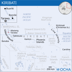
English: Locator map of Kiribati. |
| Dootem | |
| Kwel |
English: Kiribati Locator Map (ReliefWeb), ESRI, UNCS |
| Skriiwer of Konstler | |
| SVG‑Erstellung |
Lisens
- Dü mutst detdiar werk
- widjer du – detdiar werk kopiare an widjer du
- nei tuupstel – det werk feranre
- Oner jodiar konditjuunen:
- Nööm nääm – Dü skel di nööm faan di skriiwer of konstler nääm. Oober ei so, dat at so ütjsjocht, üs wan hi din werk gud fanjt.
 This map is part of a collection of 216 free country maps, created by the UN Office for the Coordination of Humanitarian Affairs (OCHA), to be used in print, web or broadcast products.
The ReliefWeb Location Maps released here are maps that highlight a country, its capital, major populated places and the surrounding regions. Attribution Requirements
Using the map without modifications: ensure that the sources and the disclaimer are below the map. Credit as follows: "Credit: OCHA". For use with alteration: remove the OCHA logo and disclaimer following any modification to the map, but keep the data sources as mentioned below the map. Credit the modified map as follows: "Based on OCHA map". You are responsible for the content of your map. We are keen to receive your feedback and hear how you used OCHA's maps. We would be grateful if you would notify us by e-mail and share your work with us. UN Disclaimer
The designations employed and the presentation of material of this map do not imply the expression of any opinion whatsoever on the part of the Secretariat of the United Nations concerning the legal status of any country, territory, city or area or of its authorities or concerning the delimitation of its frontiers or boundaries. |
Datei wersioonen
Klike üüb en tidjponkt, am detdiar wersion uuntulukin.
| Dootem/Tidj | Föörskaubil | Miaten | Brüker | Komentaar | |
|---|---|---|---|---|---|
| aktuel | 03:38, 29. Det. 2022 | | 250 × 251 (3,45 MB) | Wikijahnn | File uploaded using svgtranslate tool (https://svgtranslate.toolforge.org/). Added translation for ca. |
| 22:52, 20. Aug. 2014 |  | 250 × 251 (3,54 MB) | Pharos | == {{int:filedesc}} == {{Information |description={{en|1=Locator map of Kiribati.}} |date=2013 |source={{en|1=[http://reliefweb.int/map/kiribati/kiribati-location-map-2013 Kiribati Locator Map (ReliefWeb)], ESRI, UNCS}} |author={{en|1... |
Hü det datei brükt woort
Detdiar sidj brükt detdiar datei:
Globaal brük faan datein
Jodiar ööder Wikis brük detdiar datei:
- Brük üüb bh.wikipedia.org
- Brük üüb de.wikipedia.org
- Brük üüb fa.wikipedia.org
- Brük üüb id.wikipedia.org
- Brük üüb sd.wikipedia.org
- Brük üüb sr.wikipedia.org
_-_KIR_-_UNOCHA.svg)