
Datei:LanguageMap-Kikongo-Kituba.png

Grate faan detdiar föörskaubil: 800 × 529 pixel. Ööder apliasangen: 320 × 212 pixel | 640 × 423 pixel | 1.024 × 677 pixel | 1.420 × 939 pixel.
Originaal datei (1.420 × 939 pixels, dateigrate: 89 KB, MIME-typ: image/png)
Beskriiwang
| Beskriiwang |
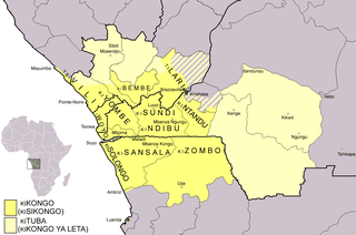
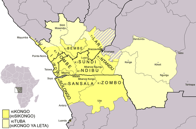
Dialect map of Kikongo. Dark yellow areas are inhabited mainly by first language speakers of the various dialects/languages of Kikongo. Names of some dialects/languages are written on the map. Pale yellow areas are inhabited by first and second language speakers of Kituba (a.k.a. Kikongo ya Leta), which is the lingua franca in the area. Kituba is understood by most speakers of Kikongo. Map drawn by Risto Kupsala. Details are based on the language maps of Ethnologue and several other sources. |
| Dootem | 2. April 2006 (Original-Hochladedatum) |
| Kwel | Die Autorenschaft wurde nicht in einer maschinell lesbaren Form angegeben. Es wird angenommen, dass es sich um ein eigenes Werk handelt (basierend auf den Rechteinhaber-Angaben). |
| Skriiwer of Konstler | Die Autorenschaft wurde nicht in einer maschinell lesbaren Form angegeben. Es wird Rasulo~commonswiki als Autor angenommen (basierend auf den Rechteinhaber-Angaben). |
Lisens
| Ik haa a rochten üüb detdiar datei an du det frei üs public domain (för arken frei). Det täält uun arke lun. Uun enkelt lunen mei det ei mögelk wees. Wan det so as: Arken koon detdiar werk brük för wat hi wal, wan det uun sin lun rochtelk mögelk as. |
Datei wersioonen
Klike üüb en tidjponkt, am detdiar wersion uuntulukin.
| Dootem/Tidj | Föörskaubil | Miaten | Brüker | Komentaar | |
|---|---|---|---|---|---|
| aktuel | 02:37, 25. Feb. 2021 | | 1.420 × 939 (89 KB) | Somebody040404 | Reverted to version as of 10:10, 29 March 2018 (UTC) |
| 02:26, 25. Feb. 2021 |  | 1.420 × 939 (82 KB) | Somebody040404 | ||
| 12:10, 29. Mar. 2018 |  | 1.420 × 939 (89 KB) | Maphobbyist | South Sudan border | |
| 23:24, 20. Det. 2007 |  | 1.420 × 939 (60 KB) | Rasulo~commonswiki | Dialect map of Kikongo. Dark yellow areas are inhabited mainly by native speakers of the various dialects/languages of Ki(si)kongo. Names of some dialects/languages are written on the map. Pale yellow areas are inhabited by first and second language speak | |
| 14:12, 22. Jul. 2006 |  | 718 × 518 (26 KB) | Rasulo~commonswiki | ||
| 11:49, 2. Apr. 2006 |  | 571 × 471 (20 KB) | Rasulo~commonswiki | Dialect map of Kikongo Dark green areas are inhabited mainly by first language speakers of the various dialects/languages of Kikongo. Names of some dialects/languages are written on the map. Light green areas are inhabited by first and second language spe |
Hü det datei brükt woort
Detdiar sidj brükt detdiar datei:
Globaal brük faan datein
Jodiar ööder Wikis brük detdiar datei:
- Brük üüb af.wikipedia.org
- Brük üüb ar.wikipedia.org
- Brük üüb ast.wikipedia.org
- Brük üüb az.wiktionary.org
- Brük üüb bn.wikipedia.org
- Brük üüb ca.wikipedia.org
- Brük üüb cs.wikipedia.org
- Brük üüb da.wikipedia.org
- Brük üüb de.wikipedia.org
- Brük üüb en.wikipedia.org
- Brük üüb eo.wikipedia.org
- Brük üüb es.wikipedia.org
- Brük üüb eu.wikipedia.org
- Brük üüb fi.wikipedia.org
- Brük üüb fr.wikipedia.org
- Brük üüb fr.wiktionary.org
Muar globaal brük faan detdiar datei.