Datei:Map of 2021 Cumbre Vieja eruption.png

Seiteninhalte werden in anderen Sprachen nicht unterstützt.
Faan Wikipedia

Originaal datei(715 × 937 pixels, dateigrate: 596 KB, MIME-typ: image/png)

Detheer bil as faan Wikimedia Commons an koon faan ööder projekten brükt wurd. Det beskriiwang faan't beskriiwangssidj woort oner uunwiset.

Beskriiwang

Beskriiwang
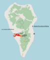
English: Map describing the 2021 Cumbre Vieja volcanic eruption, with location of the volcano shown together with the range of lava coverage (as of 23/11/2021), the capital city, airport and location of centres of destroyed localities of Todoque and La Laguna

Sources:

  • Shape of the island, land coverage, main roads, location of airport - OpenStreetMap data
  • Lava extent - Copernicus Project
  • Location of centres of towns/villages - Nomenclátor Geográfico de Municipios y Entidades de Población
  • Hillshade - processing of data from the SRTM mission
Polski: Mapa opisująca erupcję wulkanu Cumbre Vieja w 2021 roku, z lokalizacją wulkanu, zasięgiem pokrycia lawą (stan na 23.11.2021), stolicą, lotniskiem oraz zniszczonymi miejscowościami


Źródła:

  • Kształt wyspy, pokrycie terenu, główne drogi, lokalizacja lotniska - dane OpenStreetMap
  • Zasięg pokrycia lawą - Copernicus Project
  • Lokalizacja centrów miejscowości - Nomenclátor Geográfico de Municipios y Entidades de Población
  • Hillshade - przetworzone dane z misji SRTM
Dootem
Kwel Aanj werk
Skriiwer of Konstler Jakub Kaczorowski
 
Diese PNG-Rastergrafik wurde mit QGIS erstellt.

Lisens

Ik hual a rochten üüb detdiar werk, an du det frei oner det lisens:
w:de:Creative Commons
Nööm nääm Oner josalew konditjuunen widjerdu
Dü mutst detdiar werk
  • widjer du – detdiar werk kopiare an widjer du
  • nei tuupstel – det werk feranre
Oner jodiar konditjuunen:
  • Nööm nääm – Dü skel di nööm faan di skriiwer of konstler nääm. Oober ei so, dat at so ütjsjocht, üs wan hi din werk gud fanjt.
  • Oner josalew konditjuunen widjerdu – Wan dü detdiar werk feranerst, skel dü det resultaat oner detsalew lisens widjer du.

Kurzbeschreibungen

Ergänze eine einzeilige Erklärung, was diese Datei darstellt.

Urheber Tjiisk

Einige Werte ohne einen Wikidata-Eintrag

17. Oktuuber 2021

MIME-Typ Tjiisk

image/png

Datei wersioonen

Klike üüb en tidjponkt, am detdiar wersion uuntulukin.

Dootem/TidjFöörskaubilMiatenBrükerKomentaar
aktuel20:24, 24. Nof. 2021Föörskau för det wersion faan 20:24, 24. Nof. 2021715 × 937 (596 KB)Kubek15updating lava extent
12:56, 18. Nof. 2021Föörskau för det wersion faan 12:56, 18. Nof. 2021707 × 933 (592 KB)Kubek15remove double scale bar
12:53, 18. Nof. 2021Föörskau för det wersion faan 12:53, 18. Nof. 2021744 × 938 (585 KB)Kubek15Updating lava flow as of 12/11/2021
23:51, 29. Okt. 2021Föörskau för det wersion faan 23:51, 29. Okt. 2021716 × 926 (593 KB)Kubek15fixed minor graphic error
23:49, 29. Okt. 2021Föörskau för det wersion faan 23:49, 29. Okt. 2021744 × 938 (595 KB)Kubek15Added DEM, improved graphics and updated range of lava field cover
21:30, 17. Okt. 2021Föörskau för det wersion faan 21:30, 17. Okt. 2021543 × 671 (85 KB)Kubek15fixed typo
21:27, 17. Okt. 2021Föörskau för det wersion faan 21:27, 17. Okt. 2021535 × 634 (91 KB)Kubek15Uploaded own work with UploadWizard

Detdiar sidj brükt detdiar datei:

Globaal brük faan datein

Jodiar ööder Wikis brük detdiar datei:

Metadooten