
Datei:St. John, U.S. Virgin Islands.jpg

Grate faan detdiar föörskaubil: 600 × 600 pixel. Ööder apliasangen: 240 × 240 pixel | 480 × 480 pixel | 768 × 768 pixel | 1.024 × 1.024 pixel | 2.400 × 2.400 pixel.
Originaal datei (2.400 × 2.400 pixels, dateigrate: 2,74 MB, MIME-typ: image/jpeg)
Beskriiwang
| Beskriiwang |
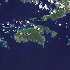
English: Natural-colour image of the Island of St. John island in the United States Virgin Islands.
|
| Dootem | |
| Kwel | NASA Earth Observatory |
| Skriiwer of Konstler | Jesse Allen and Robert Simmon |
| Ööder wersioonen |


.jpg)

Image captured by the Advanced Land Imager (ALI) on NASA’s Earth Observing-1 (EO-1) satellite. EO-1 ALI data provided courtesy of the NASA EO-1 team.
Lisens
| Diese Datei ist gemeinfrei (public domain), da sie von der NASA erstellt worden ist. Die NASA-Urheberrechtsrichtlinie besagt, dass „NASA-Material nicht durch Urheberrecht geschützt ist, wenn es nicht anders angegeben ist“. (NASA-Urheberrechtsrichtlinie-Seite oder JPL Image Use Policy). | ||
 |
Warnung:
|
| Bildnotizen | Diese Datei ist annotiert: Betrachte diese auf Commons. |
Datei wersioonen
Klike üüb en tidjponkt, am detdiar wersion uuntulukin.
| Dootem/Tidj | Föörskaubil | Miaten | Brüker | Komentaar | |
|---|---|---|---|---|---|
| aktuel | 12:13, 20. Jan. 2011 | | 2.400 × 2.400 (2,74 MB) | Originalwana | {{Information |Description={{en|1=Natural-colour image of the eastern half of St. John. Settlements—marked by curving roads and light roofs—line the irregular coastline. The pinpoints of white in Coral Bay are probably boats. The island’s interior |
Hü det datei brükt woort
Detdiar sidj brükt detdiar datei:
Globaal brük faan datein
Jodiar ööder Wikis brük detdiar datei:
- Brük üüb arz.wikipedia.org
- Brük üüb ast.wikipedia.org
- Brük üüb ca.wikipedia.org
- Brük üüb ceb.wikipedia.org
- Brük üüb cy.wikipedia.org
- Brük üüb en.wikipedia.org
- Brük üüb en.wikisource.org
- Brük üüb eo.wikipedia.org
- Brük üüb es.wikipedia.org
- Brük üüb eu.wikipedia.org
- Brük üüb fi.wikipedia.org
- Brük üüb fr.wikivoyage.org
- Brük üüb gl.wikipedia.org
- Brük üüb id.wikipedia.org
- Brük üüb lb.wikipedia.org
- Brük üüb pl.wikipedia.org
- Brük üüb tg.wikipedia.org
- Brük üüb tl.wikipedia.org
- Brük üüb uk.wikipedia.org
- Brük üüb vec.wikipedia.org
- Brük üüb www.wikidata.org