
Datei:Ukraine under russian occupation.svg

Größe der PNG-Vorschau dieser SVG-Datei: 800 × 538 pixel. Ööder apliasangen: 320 × 215 pixel | 640 × 430 pixel | 1.024 × 688 pixel | 1.280 × 860 pixel | 2.560 × 1.720 pixel | 3.780 × 2.540 pixel.
Originaal datei (SVG-datei, grate: 3.780 × 2.540 pixel, dateigrate: 1,85 MB)
Beskriiwang
| Beskriiwang |
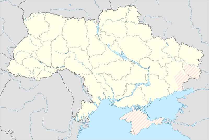
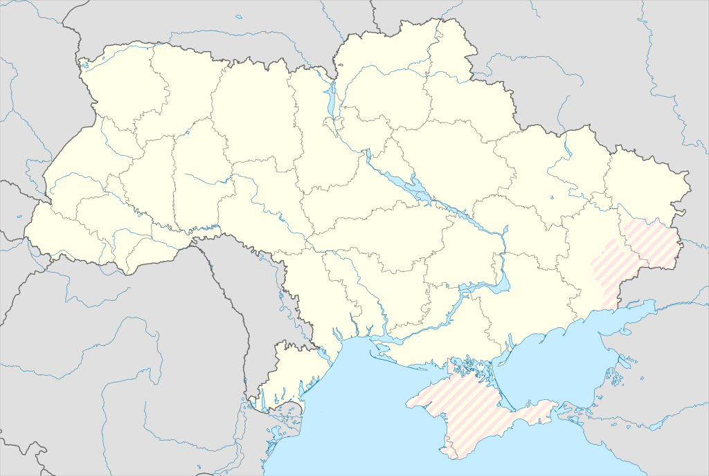
English: Location map of Ukraine under russian occupation.
Українська: Карта України з зонами російської окупації. |
| Dootem | |
| Kwel |
Eigenes Werk mittels: Ukraine adm location map improved.svg, according to
|
| Skriiwer of Konstler | Yakiv Gluck |
| Ööder wersioonen |
|
| SVG‑Erstellung | Diese Landkarte wurde mit Adobe Illustrator erstellt. |


Lisens
Ik hual a rochten üüb detdiar werk, an du det frei oner det lisens:
Diese Datei ist lizenziert unter der Creative-Commons-Lizenz „Namensnennung – Weitergabe unter gleichen Bedingungen 4.0 international“.
- Dü mutst detdiar werk
- widjer du – detdiar werk kopiare an widjer du
- nei tuupstel – det werk feranre
- Oner jodiar konditjuunen:
- Nööm nääm – Dü skel di nööm faan di skriiwer of konstler nääm. Oober ei so, dat at so ütjsjocht, üs wan hi din werk gud fanjt.
- Oner josalew konditjuunen widjerdu – Wan dü detdiar werk feranerst, skel dü det resultaat oner detsalew lisens widjer du.
Datei wersioonen
Klike üüb en tidjponkt, am detdiar wersion uuntulukin.
| Dootem/Tidj | Föörskaubil | Miaten | Brüker | Komentaar | |
|---|---|---|---|---|---|
| aktuel | 04:45, 17. Mei 2024 | | 3.780 × 2.540 (1,85 MB) | Physeters | add detail to dnipro delta |
| 17:45, 9. Aug. 2023 |  | 3.780 × 2.540 (1,36 MB) | Dƶoxar | Until the war ends it has no sense to maintain another map with actual frontline | |
| 11:32, 25. Jul. 2023 |  | 3.780 × 2.540 (1,64 MB) | ASDFPM | Reverted to version as of 17:17, 3 October 2022 (UTC) | |
| 04:45, 12. Nof. 2022 |  | 3.780 × 2.540 (1,36 MB) | Qexypnos | Reverted to version as of 17:02, 3 March 2018 (UTC) | |
| 19:17, 3. Okt. 2022 |  | 3.780 × 2.540 (1,64 MB) | Janitoalevic | Update | |
| 19:02, 3. Mar. 2018 |  | 3.780 × 2.540 (1,36 MB) | Yakiv Gluck | improved using new adm loc map | |
| 03:08, 27. Jan. 2018 |  | 1.546 × 1.038 (457 KB) | Yakiv Gluck | {{Information |Description ={{en|Location map of Ukraine under russian occupation.}} {{uk|Карта України з зонами російської окупації.}} |Source =own work, using [[:F... |
Hü det datei brükt woort
Nään artiikel brükt detheer datei
Globaal brük faan datein
Jodiar ööder Wikis brük detdiar datei:
- Brük üüb an.wikipedia.org
- Brük üüb de.wikipedia.org
- Brük üüb en.wikipedia.org
- Brük üüb es.wikipedia.org
Muar globaal brük faan detdiar datei.