Zum Inhalt springen

Datei:Indo-European branches map.png

Seiteninhalte werden in anderen Sprachen nicht unterstützt.
Faan Wikipedia

Originaal datei (2.934 × 2.938 pixels, dateigrate: 1,91 MB, MIME-typ: image/png)

Detheer bil as faan Wikimedia Commons an koon faan ööder projekten brükt wurd. Det beskriiwang faan't beskriiwangssidj woort oner uunwiset.

File:Indo-European branches map.svg ist eine vektorisierte Version dieses Bildes. Diese sollte an Stelle des Rasterbildes verwendet werden, sofern sie nicht schlechter ist.

File:Indo-European branches map.png → File:Indo-European branches map.svg

Für weitere Informationen siehe Help:SVG.

In anderen Sprachen
Alemannisch  Bahasa Indonesia  Bahasa Melayu  British English  català  čeština  dansk  Deutsch  eesti  English  español  Esperanto  euskara  français  Frysk  galego  hrvatski  Ido  italiano  lietuvių  magyar  Nederlands  norsk bokmål  norsk nynorsk  occitan  Plattdüütsch  polski  português  português do Brasil  română  Scots  sicilianu  slovenčina  slovenščina  suomi  svenska  Tiếng Việt  Türkçe  vèneto  Ελληνικά  беларуская (тарашкевіца)  български  македонски  нохчийн  русский  српски / srpski  татарча/tatarça  українська  ქართული  հայերեն  বাংলা  தமிழ்  മലയാളം  ไทย  한국어  日本語  简体中文  繁體中文  עברית  العربية  فارسی  +/−
Neue Vektorgrafik

Any autoconfirmed user can overwrite this file from the same source. Please ensure that overwrites comply with the guideline.

Beskriiwang

Beskriiwang
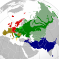
English: A map showing the approximate present-day distribution of the Indo-European branches within their homelands of Europe and Asia. The following legend is given in the chronological order of the earliest surviving written attestations of each branch:
 
Italic (includes Romance) [9]
 
Non-Indo-European languages
Dotted/striped areas indicate where multilingualism is common (more visible upon full enlargement of the map).
Dootem
Kwel

For the names of the branches, see citations in legend (based on "Indo-European Languages". The College of Liberal Arts. UT Austin. 2008.) and "Indo-European languages" from Britannica.com.

The distribution is essentially and approximately based on the map "Indo-European languages – Approximate locations of Indo-European languages in contemporary Eurasia" from Britannica.com, although with the following minor modifications:

The two articles "Balto-Slavic languages" and "Indo-Iranian languages" from Britannica.com stress the lack of scholarly consensus on these branches. That is, for the former, whether Baltic and Slavic developed from a common ancestral language, or that the similarities are the result of parallel development and of mutual influence during a long period of contact. To cater for both scholarly viewpoints, this map shows Baltic and Slavic with two distinct shades of green under "Balto-Slavic". For the latter, the dispute is whether the Indo-Iranian languages include just the Iranian and Indo-Aryan (or, Indic) language groups, or Nūristānī and Bangani too. To prevent disagreement (and also because this map only represents the primary branches of Indo-European), all of Indo-Iranian is represented with one shade.

The article "Romance languages" from Britannica.com states that the Romance languages form "a subgroup of the Italic branch of the Indo-European language family".

It should be noted that this map is only approximative and simplified, and glosses over some multilingual areas (particularly in eastern Russia, which is difficult to represent accurately). For some areas, more regional maps have been used as sources for greater accuracy, namely "Languages of Switzerland" from Ethnologue.com, "Russia ethnic plurality" from Freelang.net, "Major ethnic groups in Central Asia" from Globalsecurity.org, and "South Asian Language Families" from "Language families and branches, languages and dialects in A Historical Atlas of South Asia". Oxford University Press. New York 1992.
Skriiwer of Konstler Hayden120
Ferloof
(Hü det datei brükt woort)
Ik hual a rochten üüb detdiar werk, an du det frei oner a lisensen:
w:de:Creative Commons
Nööm nääm Oner josalew konditjuunen widjerdu
Diese Datei ist unter den Creative-Commons-Lizenzen „Namensnennung – Weitergabe unter gleichen Bedingungen 3.0 nicht portiert“, „2.5 generisch“, „2.0 generisch“ und „1.0 generisch“ lizenziert.
Dü mutst detdiar werk
  • widjer du – detdiar werk kopiare an widjer du
  • nei tuupstel – det werk feranre
Oner jodiar konditjuunen:
  • Nööm nääm – Dü skel di nööm faan di skriiwer of konstler nääm. Oober ei so, dat at so ütjsjocht, üs wan hi din werk gud fanjt.
  • Oner josalew konditjuunen widjerdu – Wan dü detdiar werk feranerst, skel dü det resultaat oner detsalew lisens widjer du.
GNU head Dü könst det datei kopiare, widjerdu of feranre efter a reegeln faan't GNU Free Documentation License, wersion 1.2 of leeder faan't Free Software Foundation; diar as niks ünferanerlik an nään tekst üüb a föör- of bääftsidj. Dü könst di lisens tekst efterlees bi GNU Free Documentation License.
Schük di ian faan jodiar lisensen ütj.

Kurzbeschreibungen

Ergänze eine einzeilige Erklärung, was diese Datei darstellt.
A map showing the approximate present-day distribution of the Indo-European branches within their homelands of Europe and Asia.

In dieser Datei abgebildete Objekte

motiif

Urheber Tjiisk

Einige Werte ohne einen Wikidata-Eintrag

16. Janewoore 2012

MIME-Typ Tjiisk

image/png

Datei wersioonen

Klike üüb en tidjponkt, am detdiar wersion uuntulukin.

(Neist | Äälst) Wise (10 neier | ) (10 | 20 | 50 | 100 | 250 | 500)
Dootem/TidjFöörskaubilMiatenBrükerKomentaar
aktuel10:28, 7. Jun. 2024Föörskau för det wersion faan 10:28, 7. Jun. 20242.934 × 2.938 (1,91 MB)Goldenupdate Karabakh
04:43, 26. Sep. 2022Föörskau för det wersion faan 04:43, 26. Sep. 20222.934 × 2.938 (2,16 MB)Alexikouaminor fixes
16:58, 30. Mar. 2022Föörskau för det wersion faan 16:58, 30. Mar. 20222.934 × 2.938 (1,74 MB)Whoop whoop pull upWhoops, wrong file!
16:37, 30. Mar. 2022Föörskau för det wersion faan 16:37, 30. Mar. 20222.048 × 2.048 (980 KB)Whoop whoop pull upMisc fixes (Russian minority in Svalbard & Israel, Slovenian in SE Carinthia, Greek in N Epirus, Aromanians/Megleno-Romanians, Swedish essentially extinct in Estonia, etc.
10:37, 22. Det. 2021Föörskau för det wersion faan 10:37, 22. Det. 20212.934 × 2.938 (1,74 MB)Ahmet Q.Reverted to version as of 19:55, 23 August 2021 (UTC)seek consensus for your changes
21:40, 25. Nof. 2021Föörskau för det wersion faan 21:40, 25. Nof. 20212.934 × 2.938 (2,16 MB)Alexikouarv elimination of Greek minority in Albania
20:55, 23. Aug. 2021Föörskau för det wersion faan 20:55, 23. Aug. 20212.934 × 2.938 (1,74 MB)Ahmet Q.Rv false edit summary. Overrepresentation of Greeks in Turkey, Albania and Ukraine. Unexplained removal of Romanian in Serbia. Overall deterioration of the original file. Seek consensus for your changes.
17:16, 7. Aug. 2021Föörskau för det wersion faan 17:16, 7. Aug. 20212.934 × 2.938 (2,16 MB)Demetrios1993Addition of Arbereshe linguistic minority in Sicily. Addition of Serbian, Bosnian, and Gorani linguistic minorities in Kosovo. Addition of Greek linguistic minorities in Italy, Albania, Turkey, and Ukraine. Including some other minor corrections.
18:00, 19. Nof. 2020Föörskau för det wersion faan 18:00, 19. Nof. 20202.934 × 2.938 (1,74 MB)Goldenupdate Armenian
19:42, 31. Mar. 2018Föörskau för det wersion faan 19:42, 31. Mar. 20181.479 × 1.479 (574 KB)MaphobbyistRemoved area that exactly corresponds to the non-Indo European Lezgi linguistic area.
(Neist | Äälst) Wise (10 neier | ) (10 | 20 | 50 | 100 | 250 | 500)

Jodiar 2 sidjen brük detdiar datei:

Globaal brük faan datein

Jodiar ööder Wikis brük detdiar datei:

Muar globaal brük faan detdiar datei.

Metadooten